ስዕል:CAN orthographic.svg

Size of this PNG preview of this SVG file: 551 × 551 pixels. Other resolutions: 240 × 240 pixels | 480 × 480 pixels | 768 × 768 pixels | 1,024 × 1,024 pixels | 2,048 × 2,048 pixels.
ዋና ፋይል (የSVG ፋይል፡ በተግባር 551 × 551 ፒክስል፤ መጠን፦ 1.83 MB)
ማጠቃለያ
| ማጠቃለያ |
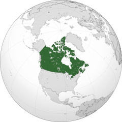
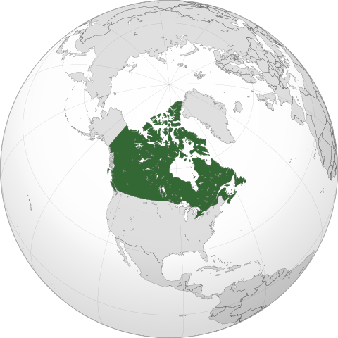
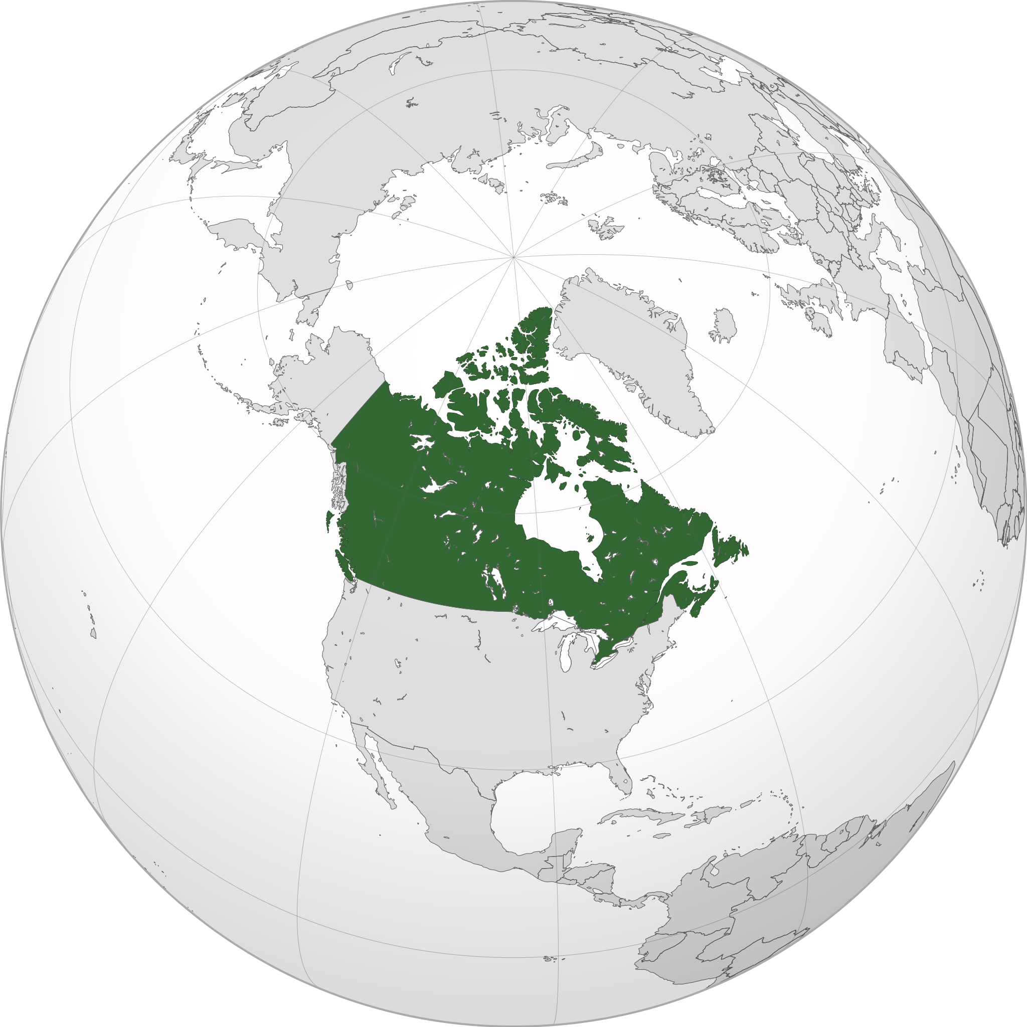
English: A map of the hemisphere centred on -95, 60, using an orthographic projection, created using gringer's Perl script with Natural Earth Data (1:50000 resolution, simplified to 0.25px). Canada is highlighted in green.
Official territory. Claimed territories. |
| ቀን | |
| ምንጭ | Own work with Natural Earth Data |
| አቅራቢው | Addicted04 |
| SVG genesis |
.svg)
.svg)
.svg)
.svg)
.svg)
.svg)
.svg)
.svg)
.svg)
.svg)
.svg)
.svg)
.svg)
.svg)
.svg)
.svg)
.svg)
.svg)
.svg)
.svg)
.svg)
.svg)
.svg)
.svg)
.svg)
.svg)
.svg)
.svg)
.svg)
.svg)
.svg)
.svg)
.svg)
.svg)
.svg)
.svg)
.svg)
.svg)
.svg)
.svg)
.svg)
.svg)
.svg)
.svg)
.svg)
.svg)
.svg)
.svg)
.svg)
.svg)
.svg)
.svg)
.svg)
.svg)
.svg)
.svg)
.svg)
.svg)
.svg)
.svg)
.svg)
.svg)
.svg)
.svg)
.svg)
.svg)
.svg)
.svg)
.svg)
.svg)
.svg)
.svg)
.svg)
.svg)

.svg)

.svg)

.svg)
.svg)
.svg)
.svg)
.svg)
.svg)
.svg)


.svg)
.svg)
.svg)
.svg)
.svg)
.svg)
.svg)

.svg)
.svg)
.svg)
.svg)
.svg)
.svg)
.svg)
.svg)
.svg)

.svg)
.svg)
.svg)
.svg)
.svg)
.svg)
.svg)
_without_national_boundaries.svg)
.svg)
.svg)
.svg)
.svg)
.svg)
.svg)

.svg)
.svg)
.png)
.svg)
.svg)
.svg)
.svg)

.svg)
.svg)
.svg)
.svg)
.svg)
.svg)
.svg)
.svg)
.svg)
.svg)
.svg)

.svg)
.svg)
.svg)
.svg)
.svg)
.svg)
.svg)
.svg)
.svg)

.svg)
.svg)

.svg)
.svg)
.svg)
.svg)
.svg)
.svg)
.svg)
.svg)
.svg)
.svg)
.svg)
.svg)
.svg)
.svg)
.svg)
.svg)
.svg)
.svg)
.svg)
.svg)
.svg)
.svg)
.svg)
.svg)
.svg)
.svg)
.svg)
_-_Crimea_disputed.svg)
.svg)
.svg)
.svg)
.svg)
.svg)
.svg)
.svg)
.svg)
.svg)
.svg)
.svg)
_political.svg)
.svg)
.svg)
.svg)
.svg)
_-_Crimea_disputed_-_no_borders.svg)
.svg)
.svg)
.svg)
.svg)
.svg)
.svg)
.svg)
.svg)
.svg)
.svg)
.svg)

.svg)
.svg)
.svg)

.png)
.svg)
.svg)
.svg)
.svg)
.svg)
.svg)
.svg)
.svg)
.svg)
.svg)
.svg)
.svg)
.svg)
.svg)
.svg)
.svg)
.svg)
.svg)
.svg)
.svg)
.svg)
.svg)
.svg)
.svg)
.svg)
.svg)
.svg)
.svg)
.svg)
.svg)
.svg)
.svg)
.svg)
.svg)
.png)
.svg)
.svg)
.svg)
_(orthographic_projection).png)
| Orthographic projections maps created by Ssolbergj |
|---|
| Orthographic projections maps created by Ssolbergj: |
.svg)
.svg)
የፈቃድ አይነት፦
I, the copyright holder of this work, hereby publish it under the following license:
This file is licensed under the Creative Commons Attribution-Share Alike 3.0 Unported license.
- You are free:
- to share – to copy, distribute and transmit the work
- to remix – to adapt the work
- Under the following conditions:
- attribution – You must give appropriate credit, provide a link to the license, and indicate if changes were made. You may do so in any reasonable manner, but not in any way that suggests the licensor endorses you or your use.
- share alike – If you remix, transform, or build upon the material, you must distribute your contributions under the same or compatible license as the original.
የፋይሉ ታሪክ
የቀድሞው ዕትም ካለ ቀን/ሰዓቱን በመጫን መመልከት ይቻላል።
| ቀን /ሰዓት | ናሙና | ክልሉ (በpixel) | አቅራቢው | ማጠቃለያ | |
|---|---|---|---|---|---|
| ያሁኑኑ | 00:05, 19 ጃንዩዌሪ 2014 | | 551 × 551 (1.83 MB) | Addicted04 | New map |
| 21:37, 19 ሴፕቴምበር 2011 |  | 550 × 550 (1.31 MB) | Addicted04 | Western islands | |
| 01:29, 19 ሴፕቴምበር 2011 |  | 550 × 550 (1.31 MB) | Addicted04 |
መያያዣዎች
የሚከተለው ገጽ ወደዚሁ ፋይል ተያይዟል፦
ሌሎች ውኪዎች
የሚከተሉት ሌሎች ውኪዎች ይህን ፋይል ይጠቀማሉ፦
- Usage on ar.wikipedia.org
- كندا
- مستخدم:وهراني/ملعب
- مستخدم:جار الله/قائمة صور مقالات العلاقات الثنائية
- العلاقات الأنغولية الكندية
- العلاقات الكندية الكورية الجنوبية
- العلاقات الإريترية الكندية
- العلاقات السويسرية الكندية
- العلاقات الألمانية الكندية
- العلاقات الكندية الليختنشتانية
- العلاقات البوليفية الكندية
- العلاقات الكندية الموزمبيقية
- العلاقات الألبانية الكندية
- العلاقات البلجيكية الكندية
- العلاقات الإثيوبية الكندية
- العلاقات البيلاروسية الكندية
- العلاقات الطاجيكستانية الكندية
- العلاقات الروسية الكندية
- العلاقات الرومانية الكندية
- العلاقات الأرجنتينية الكندية
- العلاقات الغامبية الكندية
- العلاقات القبرصية الكندية
- العلاقات السيراليونية الكندية
- العلاقات الكندية النيبالية
- العلاقات الكندية الليبيرية
- العلاقات التشيكية الكندية
- العلاقات الكندية الميانمارية
- العلاقات الزيمبابوية الكندية
- العلاقات الإسرائيلية الكندية
- العلاقات البالاوية الكندية
- العلاقات الكندية النيجيرية
- العلاقات اليمنية الكندية
- العلاقات الفانواتية الكندية
- العلاقات الغابونية الكندية
- العلاقات البنمية الكندية
- العلاقات الكندية الكوبية
- العلاقات الجورجية الكندية
- العلاقات التونسية الكندية
- العلاقات الكندية الكورية الشمالية
- العلاقات الهندية الكندية
- العلاقات الإيطالية الكندية
- العلاقات الكندية الناوروية
- العلاقات الأسترالية الكندية
- العلاقات الزامبية الكندية
- العلاقات الفيجية الكندية
- العلاقات المارشالية الكندية
- العلاقات الأذربيجانية الكندية
- العلاقات السودانية الكندية
- العلاقات الكويتية الكندية
- العلاقات الكندية الكونغوية
- العلاقات الدومينيكانية الكندية
View more global usage of this file.