ስዕል:Fiji location map.svg

Size of this PNG preview of this SVG file: 467 × 599 pixels. Other resolutions: 187 × 240 pixels | 374 × 480 pixels | 599 × 768 pixels | 798 × 1,024 pixels | 1,596 × 2,048 pixels | 728 × 934 pixels.
ዋና ፋይል (የSVG ፋይል፡ በተግባር 728 × 934 ፒክስል፤ መጠን፦ 144 KB)
ማጠቃለያ
| ማጠቃለያ |
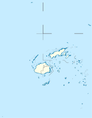
Deutsch: Positionskarte von Fidschi
Quadratische Plattkarte, N-S-Streckung 104 %. Geographische Begrenzung der Karte:
English: Location map of Fiji
Equirectangular projection, N/S stretching 104 %. Geographic limits of the map:
|
| ቀን | |
| ምንጭ |
Own work, using
|
| አቅራቢው | NordNordWest |
| የማብዛት ፈቃድ (Reusing this file) |
I, the copyright holder of this work, hereby publish it under the following license: This file is licensed under the Creative Commons Attribution-Share Alike 3.0 Unported license.
|
| ሌሎች ዕትሞች |
Derivative works of this file: |


|
This map has been made or improved in the German Kartenwerkstatt (Map Lab). You can propose maps to improve as well.
|
የፋይሉ ታሪክ
የቀድሞው ዕትም ካለ ቀን/ሰዓቱን በመጫን መመልከት ይቻላል።
| ቀን /ሰዓት | ናሙና | ክልሉ (በpixel) | አቅራቢው | ማጠቃለያ | |
|---|---|---|---|---|---|
| ያሁኑኑ | 10:19, 19 ሴፕቴምበር 2011 | | 728 × 934 (144 KB) | NordNordWest | corr |
| 16:04, 11 ኦክቶበር 2009 |  | 728 × 934 (218 KB) | NordNordWest | {{int:filedesc}} {{Information |Description= {{de|Positionskarte von Fidschi}} Quadratische Plattkarte, N-S-Streckung 104 %. Geographische Begrenzung der Karte: * N: 12.3° S * S: 21.8° S * W: 174.4° O * O: 177.9° W {{en|Location map of |
መያያዣዎች
ወዲህ ፋይል የተያያዘ ገጽ የለም።
ሌሎች ውኪዎች
የሚከተሉት ሌሎች ውኪዎች ይህን ፋይል ይጠቀማሉ፦
- Usage on af.wikipedia.org
- Usage on an.wikipedia.org
- Usage on ar.wikipedia.org
- Usage on arz.wikipedia.org
- Usage on ast.wikipedia.org
- Usage on azb.wikipedia.org
- Usage on az.wikipedia.org
- Usage on ba.wikipedia.org
- Usage on be-tarask.wikipedia.org
- Usage on be.wikipedia.org
- Usage on bg.wikipedia.org
View more global usage of this file.