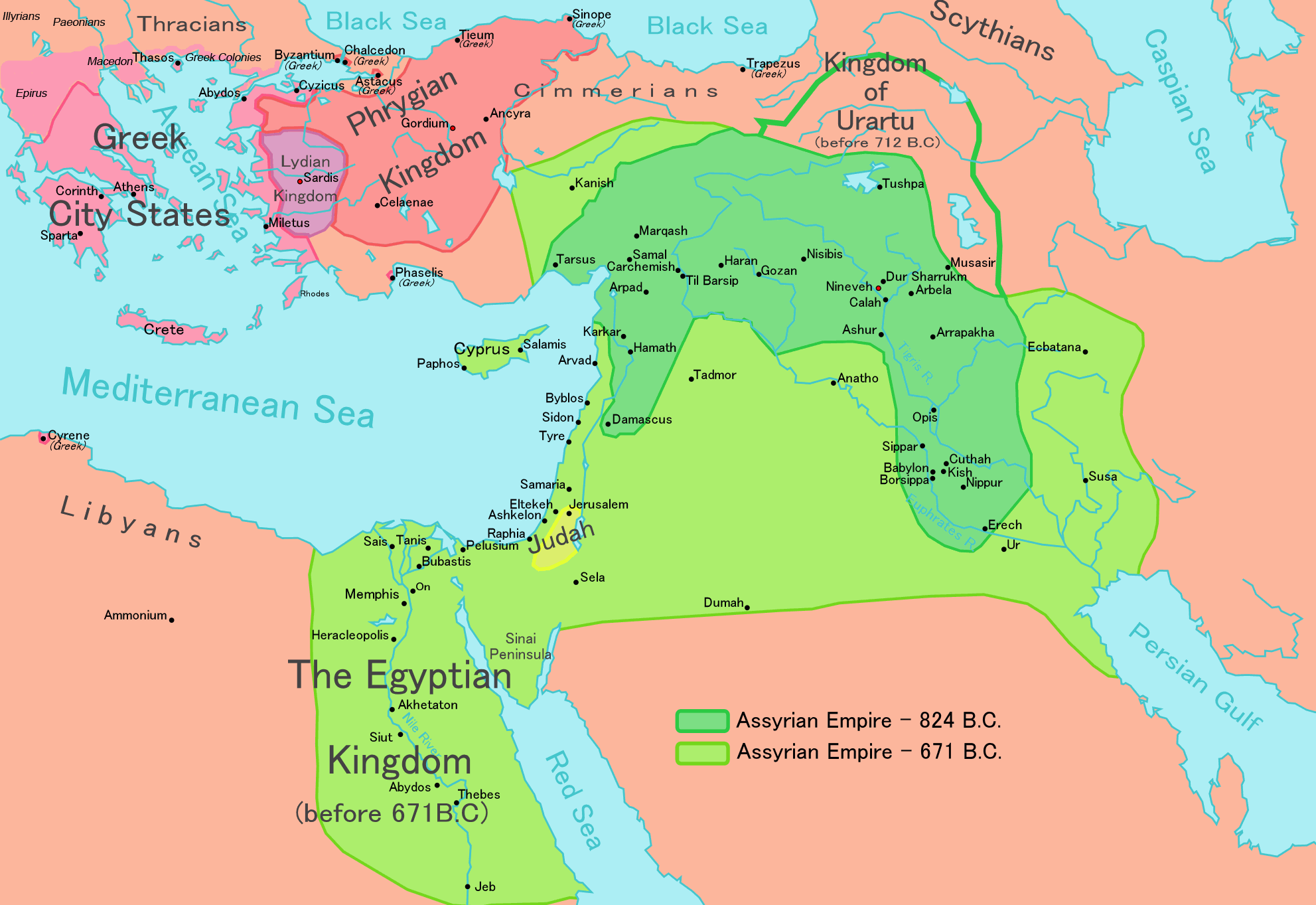
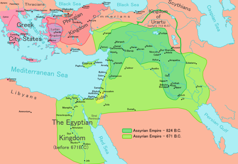
ስዕል:Map of Assyria.png
Size of this preview: 800 × 550 pixels. Other resolutions: 320 × 220 pixels | 640 × 440 pixels | 1,024 × 704 pixels | 1,280 × 880 pixels | 1,983 × 1,363 pixels.
ዋና ፋይል (1,983 × 1,363 ፒክስል፤ መጠን፦ 160 KB፤ የMIME ዓይነት፦ image/png)
| ማጠቃለያ |
[] English: Map of the Assyrian Empire Español: Extensión del Imperio Asirio Polski: Mapa Asyrii w 824 i 671 r. p.n.e. Português: Extensão do Império Assírio العربية : خارطة الإمبراطوريَّة الآشوريَّة. فارسی : نقشه امپراتوری آشور |
|||
| ቀን | ||||
| ምንጭ |
Own work data from
|
|||
| አቅራቢው | Ningyou | |||
| የማብዛት ፈቃድ (Reusing this file) |
|
|||
| ሌሎች ዕትሞች |
[]
|


የፋይሉ ታሪክ
የቀድሞው ዕትም ካለ ቀን/ሰዓቱን በመጫን መመልከት ይቻላል።
| ቀን /ሰዓት | ናሙና | ክልሉ (በpixel) | አቅራቢው | ማጠቃለያ | |
|---|---|---|---|---|---|
| ያሁኑኑ | 12:32, 24 ሜይ 2018 | | 1,983 × 1,363 (160 KB) | Capmo | corrected typos in Trapezus and Hamath |
| 18:33, 12 ሴፕቴምበር 2010 |  | 1,983 × 1,363 (148 KB) | Ras67 | cropped and squeezed | |
| 00:35, 1 ሴፕቴምበር 2010 |  | 1,985 × 1,365 (161 KB) | Capmo | typo in word "Aegean"; 256 colors | |
| 21:05, 21 ጃንዩዌሪ 2010 |  | 1,985 × 1,365 (645 KB) | Megistias | Border around map, Details | |
| 14:51, 26 ፌብሩዌሪ 2006 |  | 1,985 × 1,365 (640 KB) | Ningyou | This is a large map of Assyria, made by Ningyou. For translations of this map, contact Ningyou. Category:Assyria |
መያያዣዎች
የሚከተለው ገጽ ወደዚሁ ፋይል ተያይዟል፦
ሌሎች ውኪዎች
የሚከተሉት ሌሎች ውኪዎች ይህን ፋይል ይጠቀማሉ፦
- Usage on af.wikipedia.org
- Usage on als.wikipedia.org
- Usage on an.wikipedia.org
- Usage on arc.wikipedia.org
- Usage on ar.wikipedia.org
- Usage on ast.wikipedia.org
- Usage on azb.wikipedia.org
- Usage on az.wikipedia.org
- Usage on ba.wikipedia.org
- Usage on be.wikipedia.org
- Usage on bg.wikipedia.org
- Usage on bn.wikipedia.org
- Usage on ca.wikipedia.org
- Usage on ckb.wikipedia.org
- Usage on cs.wikipedia.org
- Usage on cv.wikipedia.org
- Usage on cy.wikipedia.org
- Usage on dag.wikipedia.org
- Usage on da.wikipedia.org
- Usage on de.wikipedia.org
- Usage on el.wikipedia.org
View more global usage of this file.