ስዕል:Borneo2 map english names.PNG

Size of this preview: 539 × 600 pixels. Other resolutions: 216 × 240 pixels | 431 × 480 pixels | 690 × 768 pixels | 1,063 × 1,183 pixels.
ዋና ፋይል (1,063 × 1,183 ፒክስል፤ መጠን፦ 236 KB፤ የMIME ዓይነት፦ image/png)
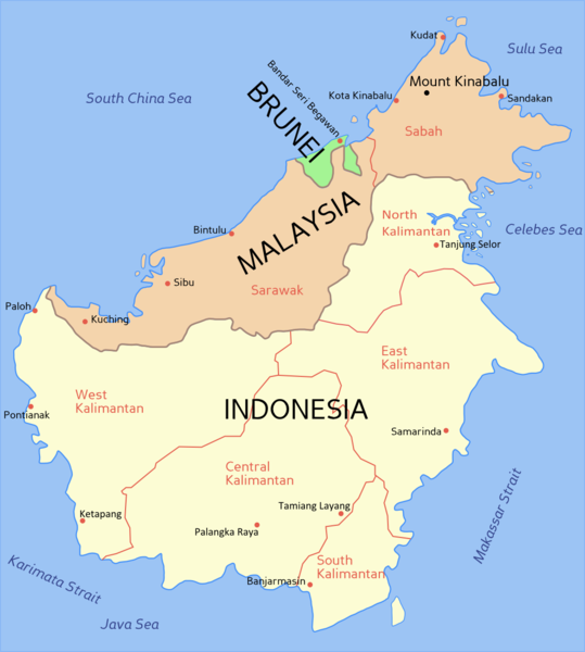
ማጠቃለያ
(English) Political map of Borneo, based on information from several maps.
- Light yellow = Indonesia
- Light orange = Malaysia
- Green = Brunei
For a blank political map see Image:Borneo blank map.PNG
(Bahasa Melayu) Peta Borneo, berdasarkan maklumat dari beberapa peta berlainan.
- Kuning cair = Indonesia
- Oren cair = Malaysia
- Hijau = Brunei
Untuk melihat peta Borneo kosong, sila ke Image:Borneo blank map.PNG

|
File:Borneo2 map english names.svg is a vector version of this file. It should be used in place of this PNG file when not inferior.
File:Borneo2 map english names.PNG → File:Borneo2 map english names.svg
For more information, see Help:SVG. |
 |
የፈቃድ አይነት፦

|
Permission is granted to copy, distribute and/or modify this document under the terms of the GNU Free Documentation License, Version 1.2 or any later version published by the Free Software Foundation; with no Invariant Sections, no Front-Cover Texts, and no Back-Cover Texts. A copy of the license is included in the section entitled GNU Free Documentation License. |
| This file is licensed under the Creative Commons Attribution-Share Alike 3.0 Unported license. | ||
| ||
| This licensing tag was added to this file as part of the GFDL licensing update. |
የፋይሉ ታሪክ
የቀድሞው ዕትም ካለ ቀን/ሰዓቱን በመጫን መመልከት ይቻላል።
| ቀን /ሰዓት | ናሙና | ክልሉ (በpixel) | አቅራቢው | ማጠቃለያ | |
|---|---|---|---|---|---|
| ያሁኑኑ | 15:54, 30 ኦክቶበር 2012 | | 1,063 × 1,183 (236 KB) | Exagren | revision, +North Kalimantan |
| 12:49, 24 ጁን 2006 |  | 1,063 × 1,183 (73 KB) | Roke~commonswiki | blue text labels on ocean | |
| 10:41, 20 ፌብሩዌሪ 2006 |  | 1,063 × 1,183 (69 KB) | Roke~commonswiki | Map of Borneo, based on information from several maps. *Light yellow = Indonesia *Light Orange = Malaysia *Green = Brunei For a blank map see Image:Borneo blank map.PNG Category: Indonesia Category: Malaysia Category: Brunei |
መያያዣዎች
ወዲህ ፋይል የተያያዘ ገጽ የለም።
ሌሎች ውኪዎች
የሚከተሉት ሌሎች ውኪዎች ይህን ፋይል ይጠቀማሉ፦
- Usage on ar.wikipedia.org
- Usage on bcl.wikipedia.org
- Usage on br.wikipedia.org
- Usage on ca.wikipedia.org
- Usage on ceb.wikipedia.org
- Usage on ckb.wikipedia.org
- Usage on cs.wikipedia.org
- Usage on cy.wikipedia.org
- Usage on da.wikipedia.org
- Usage on en.wikipedia.org
- Usage on fi.wikipedia.org
- Usage on frr.wikipedia.org
- Usage on fr.wikipedia.org
- Usage on fr.wikinews.org
- Usage on gd.wikipedia.org
- Usage on he.wikipedia.org
- Usage on id.wikipedia.org
- Usage on ja.wikipedia.org
- Usage on jv.wikipedia.org
- Usage on la.wikipedia.org
- Usage on map-bms.wikipedia.org
- Usage on min.wikipedia.org
- Usage on mr.wikipedia.org
- Usage on ms.wikipedia.org
- Usage on nl.wikipedia.org
- Usage on nn.wikipedia.org
- Usage on no.wikipedia.org
- Usage on pam.wikipedia.org
- Usage on pl.wikipedia.org
- Usage on pt.wikipedia.org
- Usage on scn.wikipedia.org
- Usage on sk.wikipedia.org
- Usage on sv.wikipedia.org
- Usage on ta.wikipedia.org
- Usage on ta.wikinews.org
- Usage on tg.wikipedia.org
- Usage on tl.wikipedia.org
- Usage on tr.wiktionary.org
View more global usage of this file.