ስዕል:Thrace and present-day state borderlines.png

Size of this preview: 501 × 600 pixels. Other resolutions: 200 × 240 pixels | 593 × 710 pixels.
ዋና ፋይል (593 × 710 ፒክስል፤ መጠን፦ 142 KB፤ የMIME ዓይነት፦ image/png)
ማጠቃለያ
| Description |
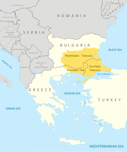
English: Thrace and present-day state borderlines
Български: Тракия и съвременните държавни граници |
|||||||||
| ቀን | ||||||||||
| ምንጭ | File:Thrace modern state boundaries.png | |||||||||
| Creator | ||||||||||
| Geotemporal data | ||||||||||
| Bounding box |
|
|||||||||
| Georeferencing | ||||||||||
| ሌሎች ዕትሞች | File:Thrace modern state boundaries.png, File:Thrace and present-day state borderlines zh.png, File:Thrace and present-day state borderlines-ar.png | |||||||||
የፈቃድ አይነት፦
I, the copyright holder of this work, hereby publish it under the following licenses:
This file is licensed under the Creative Commons Attribution-Share Alike 3.0 Unported license.
- You are free:
- to share – to copy, distribute and transmit the work
- to remix – to adapt the work
- Under the following conditions:
- attribution – You must give appropriate credit, provide a link to the license, and indicate if changes were made. You may do so in any reasonable manner, but not in any way that suggests the licensor endorses you or your use.
- share alike – If you remix, transform, or build upon the material, you must distribute your contributions under the same or compatible license as the original.

|
Permission is granted to copy, distribute and/or modify this document under the terms of the GNU Free Documentation License, Version 1.2 or any later version published by the Free Software Foundation; with no Invariant Sections, no Front-Cover Texts, and no Back-Cover Texts. A copy of the license is included in the section entitled GNU Free Documentation License. |
You may select the license of your choice.

|
This map image could be re-created using vector graphics as an SVG file. This has several advantages; see Commons:Media for cleanup for more information. If an SVG form of this image is available, please upload it and afterwards replace this template with
{{vector version available|new image name}}.
It is recommended to name the SVG file “Thrace and present-day state borderlines.svg”—then the template Vector version available (or Vva) does not need the new image name parameter. |
የፋይሉ ታሪክ
የቀድሞው ዕትም ካለ ቀን/ሰዓቱን በመጫን መመልከት ይቻላል።
| ቀን /ሰዓት | ናሙና | ክልሉ (በpixel) | አቅራቢው | ማጠቃለያ | |
|---|---|---|---|---|---|
| ያሁኑኑ | 09:17, 6 ኦክቶበር 2017 | | 593 × 710 (142 KB) | Mélomène | Details |
| 09:57, 24 ኦክቶበር 2009 |  | 593 × 710 (145 KB) | Пакко | again | |
| 09:56, 24 ኦክቶበር 2009 |  | 600 × 710 (154 KB) | Пакко | some changes | |
| 09:55, 24 ኦክቶበር 2009 |  | 3,292 × 3,897 (1.06 MB) | Пакко | SOME CHANGEIS | |
| 19:20, 16 ኦገስት 2009 |  | 583 × 800 (157 KB) | Пакко | some changes | |
| 13:02, 15 ኦገስት 2009 |  | 3,074 × 3,750 (954 KB) | Пакко | {{Information |Description={{en|1=Thrace and present-day state borderlines}} {{bg|1=Тракия и съвременните държавни граници}} |Source=File:Thrace modern state boundaries.png |Author=Пакко |Dat |
መያያዣዎች
የሚከተለው ገጽ ወደዚሁ ፋይል ተያይዟል፦
ሌሎች ውኪዎች
የሚከተሉት ሌሎች ውኪዎች ይህን ፋይል ይጠቀማሉ፦
- Usage on af.wikipedia.org
- Usage on ast.wikipedia.org
- Usage on azb.wikipedia.org
- Usage on ba.wikipedia.org
- Usage on bg.wikipedia.org
- Usage on bn.wikipedia.org
- Usage on br.wikipedia.org
- Usage on bs.wikipedia.org
- Usage on bs.wiktionary.org
- Usage on ca.wikipedia.org
- Usage on ckb.wikipedia.org
- Usage on crh.wikipedia.org
- Usage on cs.wikipedia.org
- Usage on cs.wiktionary.org
- Usage on da.wikipedia.org
- Usage on de.wikipedia.org
- Usage on de.wikivoyage.org
- Usage on el.wikipedia.org
- Usage on en.wikipedia.org
- Usage on en.wikiversity.org
- Usage on en.wikivoyage.org
- Usage on en.wiktionary.org
- Usage on eo.wikipedia.org
- Usage on es.wikipedia.org
- Usage on et.wikipedia.org
- Usage on eu.wikipedia.org
- Usage on fa.wikipedia.org
- Usage on fi.wikipedia.org
- Usage on fr.wikipedia.org
- Usage on fr.wiktionary.org
- Usage on ga.wikipedia.org
- Usage on gl.wikipedia.org
- Usage on hi.wikipedia.org
- Usage on hr.wikipedia.org
- Usage on hr.wiktionary.org
- Usage on hy.wikipedia.org
- Usage on hyw.wikipedia.org
- Usage on ia.wikipedia.org
- Usage on id.wikipedia.org
View more global usage of this file.