ስዕል:Map of Scandinavia.png
Size of this preview: 731 × 600 pixels. Other resolutions: 293 × 240 pixels | 585 × 480 pixels | 780 × 640 pixels.
ዋና ፋይል (780 × 640 ፒክስል፤ መጠን፦ 30 KB፤ የMIME ዓይነት፦ image/png)

|
This file has been superseded by Map of Scandinavia.svg. It is recommended to use the other file. Please note that deleting superseded images requires consent.
|

|
ማጠቃለያ
| ማጠቃለያ |
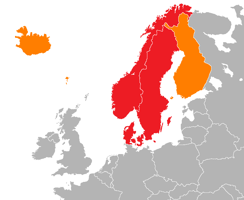
English: Map showing two of the common definitions of "Scandinavia"; a cultural, historical and ethno-linguistic region in northern Europe:
the most common usage: the three monarchies; Denmark, Norway and Sweden
an extended usage: including Finland, Iceland and the Faroe Islands
Українська: Карта показує два визначення "Скандинавії"; культурного, історичного та етно-лінгвістичного регіону в Північній Європі:
звичайне визначення: три монархії; Данія, Норвегія та Швеція
розширене визначення: включає Фінляндію, Ісландію та Фарерські острови |
| ቀን | |
| ምንጭ | Own work |
| አቅራቢው | 000peter |
የፈቃድ አይነት፦
I, the copyright holder of this work, hereby publish it under the following license:
This file is licensed under the Creative Commons Attribution-Share Alike 3.0 Unported license.
- You are free:
- to share – to copy, distribute and transmit the work
- to remix – to adapt the work
- Under the following conditions:
- attribution – You must give appropriate credit, provide a link to the license, and indicate if changes were made. You may do so in any reasonable manner, but not in any way that suggests the licensor endorses you or your use.
- share alike – If you remix, transform, or build upon the material, you must distribute your contributions under the same or compatible license as the original.
የፋይሉ ታሪክ
የቀድሞው ዕትም ካለ ቀን/ሰዓቱን በመጫን መመልከት ይቻላል።
| ቀን /ሰዓት | ናሙና | ክልሉ (በpixel) | አቅራቢው | ማጠቃለያ | |
|---|---|---|---|---|---|
| ያሁኑኑ | 19:04, 15 ኤፕሪል 2012 | | 780 × 640 (30 KB) | Hazhk | More detail (using a new base) |
| 09:40, 10 ሴፕቴምበር 2011 |  | 717 × 548 (19 KB) | Hazhk | Making the Faroe Islands more visible (drawing the rough shape of the island group rather than a blob) | |
| 12:28, 5 ሴፕቴምበር 2011 |  | 753 × 548 (20 KB) | Hazhk |
መያያዣዎች
ወዲህ ፋይል የተያያዘ ገጽ የለም።
ሌሎች ውኪዎች
የሚከተሉት ሌሎች ውኪዎች ይህን ፋይል ይጠቀማሉ፦
- Usage on en.wikipedia.org
- Usage on rm.wikipedia.org