ስዕል:Global Temperature Anomaly 1880-2010 (Fig.A).gif
ከዚህ በላይ ማጉላት አይቻልም።
Global_Temperature_Anomaly_1880-2010_(Fig.A).gif (658 × 474 ፒክስል፤ መጠን፦ 30 KB፤ የMIME ዓይነት፦ image/gif)
ማጠቃለያ
| ማጠቃለያ |
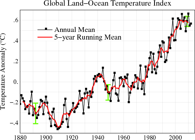
English: Line plot of global mean land-ocean temperature index, 1880 to present, with the base period 1951-1980. The black line is the annual mean and the red line is the five-year running mean. The green bars show uncertainty estimates. [This is an update of Fig. 1A in Hansen et al. (2006).] The graph shows an overall long-term warming trend. |
|||||
| ቀን | ||||||
| ምንጭ | http://data.giss.nasa.gov/gistemp/ | |||||
| አቅራቢው | NASA Goddard Institute for Space Studies | |||||
| የማብዛት ፈቃድ (Reusing this file) |
|
|||||
| ሌሎች ዕትሞች |
PDF version: File:Global_Temperature_Anomaly_1880-2010_(Fig.A).pdf. SVG version (1880-2010 data, 1961-1990 base period): File:Instrumental Temperature Record (NASA).svg
|

.svg)

|
File:Global Temperature Anomaly.svg is a vector version of this file. It should be used in place of this GIF file when not inferior.
File:Global Temperature Anomaly 1880-2010 (Fig.A).gif → File:Global Temperature Anomaly.svg
For more information, see Help:SVG. |
 |
የፋይሉ ታሪክ
የቀድሞው ዕትም ካለ ቀን/ሰዓቱን በመጫን መመልከት ይቻላል።
| ቀን /ሰዓት | ናሙና | ክልሉ (በpixel) | አቅራቢው | ማጠቃለያ | |
|---|---|---|---|---|---|
| ያሁኑኑ | 15:56, 21 ጁን 2013 | | 658 × 474 (30 KB) | Nigelj | Upload version that has been updated with 2012 data |
| 21:20, 19 ጃንዩዌሪ 2012 |  | 652 × 474 (31 KB) | Simplex1swrhs | I have uploaded a new version of the NASA global temperature graph with 2011 data. | |
| 15:58, 19 ማርች 2011 |  | 652 × 474 (31 KB) | Simplex1swrhs | Switched back to the NASA GISS "Global Land-Ocean Temperature Index" graph with 2010 data update. {{Information |Description= Line plot of global mean land-ocean temperature index, 1880 to present, with the base period 1951-1980. The dotted black line is | |
| 20:05, 3 ማርች 2011 |  | 655 × 439 (30 KB) | OKIsItJustMe | {{Information |Description ={{en|1=Line plot of global mean land-ocean temperature index, 1880 to present, with the base period 1951-1980. The dotted black line is the annual mean and the solid red line is the five-year mean. The green bars show uncert |
መያያዣዎች
ወዲህ ፋይል የተያያዘ ገጽ የለም።
ሌሎች ውኪዎች
የሚከተሉት ሌሎች ውኪዎች ይህን ፋይል ይጠቀማሉ፦
- Usage on ar.wikipedia.org
- Usage on en.wikipedia.org
- Usage on fr.wikipedia.org
- Usage on ko.wikipedia.org
- Usage on no.wikipedia.org
- Usage on vi.wikipedia.org
- Usage on zh.wikipedia.org
.gif)