ስዕል:Carte du Mitanni.png

Size of this preview: 800 × 534 pixels. Other resolutions: 320 × 214 pixels | 640 × 427 pixels | 1,024 × 683 pixels | 1,272 × 849 pixels.
ዋና ፋይል (1,272 × 849 ፒክስል፤ መጠን፦ 1.51 MB፤ የMIME ዓይነት፦ image/png)
| ማጠቃለያ |
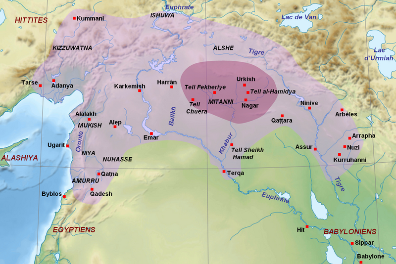
English: Map of the kingdom of Mitanni at its maximal extension, with the main cities and archaeological sites. Adapted from F. Joannès (dir.), Dictionnaire de la civilisation mésopotamienne, Paris, 2001, p. 534 (map by M. Sauvage and B. Lion), and M. Roaf, Cultural Atlas of Mesopotamia and the Ancient Near East, Oxford, 2004, p. 134 with the addition of Terqa among the vassals of Mitanni. Dark purple : the mitannian heartland ; light purple : the approximate maximal extension of the mitannian dominion.
Français : Carte du royaume du Mitanni avec ses limites approximatives à son apogée avec les principales villes et sites archéologiques. Adapté de F. Joannès (dir.), Dictionnaire de la civilisation mésopotamienne, Paris, 2001, p. 534 (carte de M. Sauvage et B. Lion), et M. Roaf, Cultural Atlas of Mesopotamia and the Ancient Near East, Oxford, 2004, p. 134, avec l'ajout de Terqa parmi les vassaux du Mitanni. Mauve foncé : le cœur du Mitanni ; mauve clair : les limites approximatives de l'extension maximale de la domination du Mitanni au début du XVe siècle av. J.-C. |
| ቀን | (UTC) |
| ምንጭ | |
| አቅራቢው |
|
| ሌሎች ዕትሞች |
[]
|


| This is a retouched picture, which means that it has been digitally altered from its original version. Modifications: Ajout des sites du Mitanni et de l'étendue du royaume. The original can be viewed here: Near East topographic map-blank.svg:
|
I, the copyright holder of this work, hereby publish it under the following licenses:
This file is licensed under the Creative Commons Attribution-Share Alike 3.0 Unported, 2.5 Generic, 2.0 Generic and 1.0 Generic license.
- You are free:
- to share – to copy, distribute and transmit the work
- to remix – to adapt the work
- Under the following conditions:
- attribution – You must give appropriate credit, provide a link to the license, and indicate if changes were made. You may do so in any reasonable manner, but not in any way that suggests the licensor endorses you or your use.
- share alike – If you remix, transform, or build upon the material, you must distribute your contributions under the same or compatible license as the original.

|
Permission is granted to copy, distribute and/or modify this document under the terms of the GNU Free Documentation License, Version 1.2 or any later version published by the Free Software Foundation; with no Invariant Sections, no Front-Cover Texts, and no Back-Cover Texts. A copy of the license is included in the section entitled GNU Free Documentation License. |
You may select the license of your choice.
Original upload log
This image is a derivative work of the following images:
- File:Near_East_topographic_map-blank.svg licensed with Cc-by-sa-3.0,2.5,2.0,1.0, GFDL
- 2009-08-18T18:31:37Z Sémhur 2425x1581 (2442670 Bytes) 3 - New try
- 2009-08-17T15:39:22Z Sémhur 2425x1581 (1815374 Bytes) 2 - With the background...
- 2009-08-17T15:37:36Z Sémhur 2425x1581 (2836 Bytes) {{Information |Description={{en|1=Blank physical map of the [[:en:Near East|Near East]]}} {{fr|1=Carte physique vierge du [[:fr:Proche-Orient|Proche-Orient]].}} |Source={{own}} |Author=[[User:Sémhur|Sémhur]] |Date=2008-08-1
Uploaded with derivativeFX
የፋይሉ ታሪክ
የቀድሞው ዕትም ካለ ቀን/ሰዓቱን በመጫን መመልከት ይቻላል።
| ቀን /ሰዓት | ናሙና | ክልሉ (በpixel) | አቅራቢው | ማጠቃለያ | |
|---|---|---|---|---|---|
| ያሁኑኑ | 14:00, 23 ሴፕቴምበር 2010 | | 1,272 × 849 (1.51 MB) | Zunkir | Ajout de Qattara, corrections mineures. |
| 13:57, 23 ሴፕቴምበር 2010 |  | 1,272 × 849 (1.51 MB) | Zunkir | Coloriage de l'extension du Mitanni, et de sa région centrale, ajout de villes et des noms des cours d'eau. | |
| 11:49, 21 ሴፕቴምበር 2010 |  | 1,173 × 797 (1.42 MB) | Zunkir | {{Information |Description={{en|1=Map of the kingdom of Mitanni at its maximal extension, with the main cities and archeological sites.}} {{fr|Carte du royaume du Mitanni à son apogée avec les principales villes et sites archéologiques.}} |Source=*[[: |
መያያዣዎች
ሌሎች ውኪዎች
የሚከተሉት ሌሎች ውኪዎች ይህን ፋይል ይጠቀማሉ፦
- Usage on ar.wikipedia.org
- Usage on arz.wikipedia.org
- Usage on ast.wikipedia.org
- Usage on ba.wikipedia.org
- Usage on be-tarask.wikipedia.org
- Usage on bg.wikipedia.org
- Usage on bn.wikipedia.org
- Usage on br.wikipedia.org
- Usage on ceb.wikipedia.org
- Usage on ckb.wikipedia.org
- Usage on cs.wikipedia.org
- Usage on de.wikipedia.org
- Usage on el.wikipedia.org
- Usage on en.wikipedia.org
- Usage on eo.wikipedia.org
- Usage on fa.wikipedia.org
- Usage on fi.wikipedia.org
- Usage on fr.wikipedia.org
- Usage on gl.wikipedia.org
- Usage on hi.wikipedia.org
- Usage on id.wikipedia.org
- Usage on it.wikipedia.org
- Usage on ja.wikipedia.org
- Usage on lt.wikipedia.org
- Usage on lv.wikipedia.org
- Usage on ne.wikipedia.org
- Usage on nl.wikipedia.org
- Usage on pl.wikipedia.org
View more global usage of this file.