ስዕል:Amarnamap.png

Size of this preview: 772 × 599 pixels. Other resolutions: 309 × 240 pixels | 619 × 480 pixels | 782 × 607 pixels.
ዋና ፋይል (782 × 607 ፒክስል፤ መጠን፦ 743 KB፤ የMIME ዓይነት፦ image/png)
ማጠቃለያ

|
This map has been uploaded by Electionworld from en.wikipedia.org to enable the |
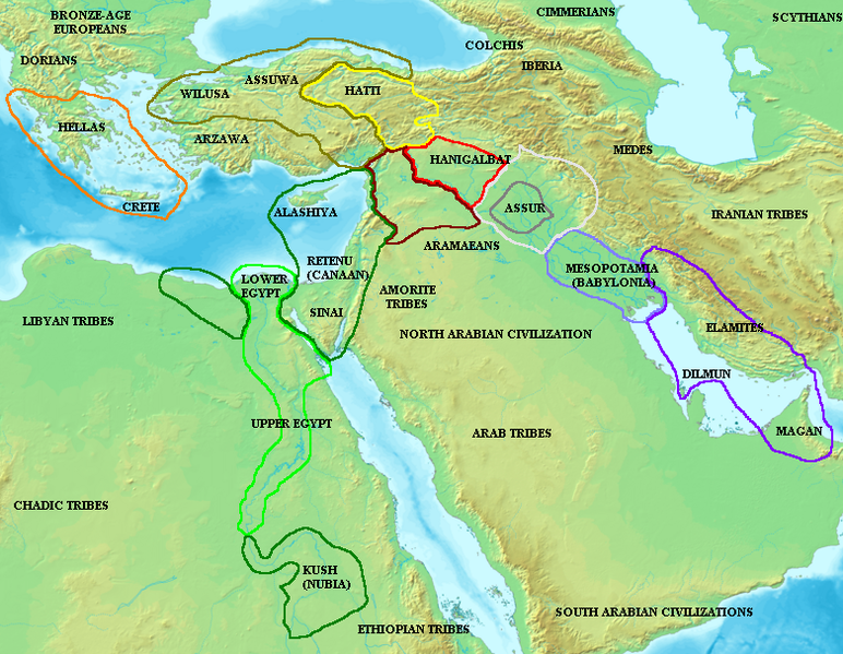
Map of the ancient Near East during the Amarna period, showing the great powers of the period: Egypt (green), Hatti (yellow), the Kassite kingdom of Babylon (purple), Assyria (grey), and Mittani (red). Lighter areas show direct control, darker areas represent spheres of influence. The extent of the Achaean/Mycenaean civilization is shown in orange.
On the map above: the territory between Medes and Iberia was called Ararat or Armenia, around the lake Van.
የፈቃድ አይነት፦
I, the copyright holder of this work, hereby publish it under the following license:

|
Permission is granted to copy, distribute and/or modify this document under the terms of the GNU Free Documentation License, Version 1.2 or any later version published by the Free Software Foundation; with no Invariant Sections, no Front-Cover Texts, and no Back-Cover Texts. A copy of the license is included in the section entitled GNU Free Documentation License. |
| This file is licensed under the Creative Commons Attribution-Share Alike 3.0 Unported license. | ||
| ||
| This licensing tag was added to this file as part of the GFDL licensing update. |
የፋይሉ ታሪክ
የቀድሞው ዕትም ካለ ቀን/ሰዓቱን በመጫን መመልከት ይቻላል።
| ቀን /ሰዓት | ናሙና | ክልሉ (በpixel) | አቅራቢው | ማጠቃለያ | |
|---|---|---|---|---|---|
| ያሁኑኑ | 09:55, 3 ዲሴምበር 2006 | | 782 × 607 (743 KB) | Electionworld | {{ew|en|Briangotts}} Map of the ancient Near East during the Amarna period, showing the great powers of the period: Egypt (green), Hatti (yellow), the Kassite kingdom of Babylon (purple), Assyria (grey), and Mittani (red). |
መያያዣዎች
የሚከተለው ገጽ ወደዚሁ ፋይል ተያይዟል፦
ሌሎች ውኪዎች
የሚከተሉት ሌሎች ውኪዎች ይህን ፋይል ይጠቀማሉ፦
- Usage on ar.wikipedia.org
- Usage on ast.wikipedia.org
- Usage on ba.wikipedia.org
- Usage on be.wikipedia.org
- Usage on bs.wikipedia.org
- Usage on ca.wikipedia.org
- Usage on diq.wikipedia.org
- Usage on el.wikipedia.org
- Usage on en.wikipedia.org
- Usage on es.wikipedia.org
- Usage on eu.wikipedia.org
- Usage on fi.wikipedia.org
- Usage on fr.wikipedia.org
- Usage on fy.wikipedia.org
- Usage on he.wikipedia.org
- Usage on hu.wikipedia.org
- Usage on hy.wikipedia.org
- Usage on hyw.wikipedia.org
- Usage on id.wikipedia.org
- Usage on ja.wikipedia.org
- Usage on jv.wikipedia.org
- Usage on mk.wikipedia.org
- Usage on ml.wikipedia.org
- Usage on nl.wikipedia.org
- Usage on no.wikipedia.org
View more global usage of this file.