ስዕል:1780 Raynal and Bonne Map of Arabia and Abyssinia - Geographicus - Arabie-bonne-1780.jpg
Size of this preview: 800 × 551 pixels. Other resolutions: 320 × 221 pixels | 640 × 441 pixels | 1,024 × 706 pixels | 1,280 × 882 pixels | 2,500 × 1,723 pixels.
ዋና ፋይል (2,500 × 1,723 ፒክስል፤ መጠን፦ 1.31 MB፤ የMIME ዓይነት፦ image/jpeg)
| Rigobert Bonne: Carte De L'Arabie
( |
|||||||||||||||||||||||
|---|---|---|---|---|---|---|---|---|---|---|---|---|---|---|---|---|---|---|---|---|---|---|---|
| አርቲስት |
|
||||||||||||||||||||||
| ርዕስ |
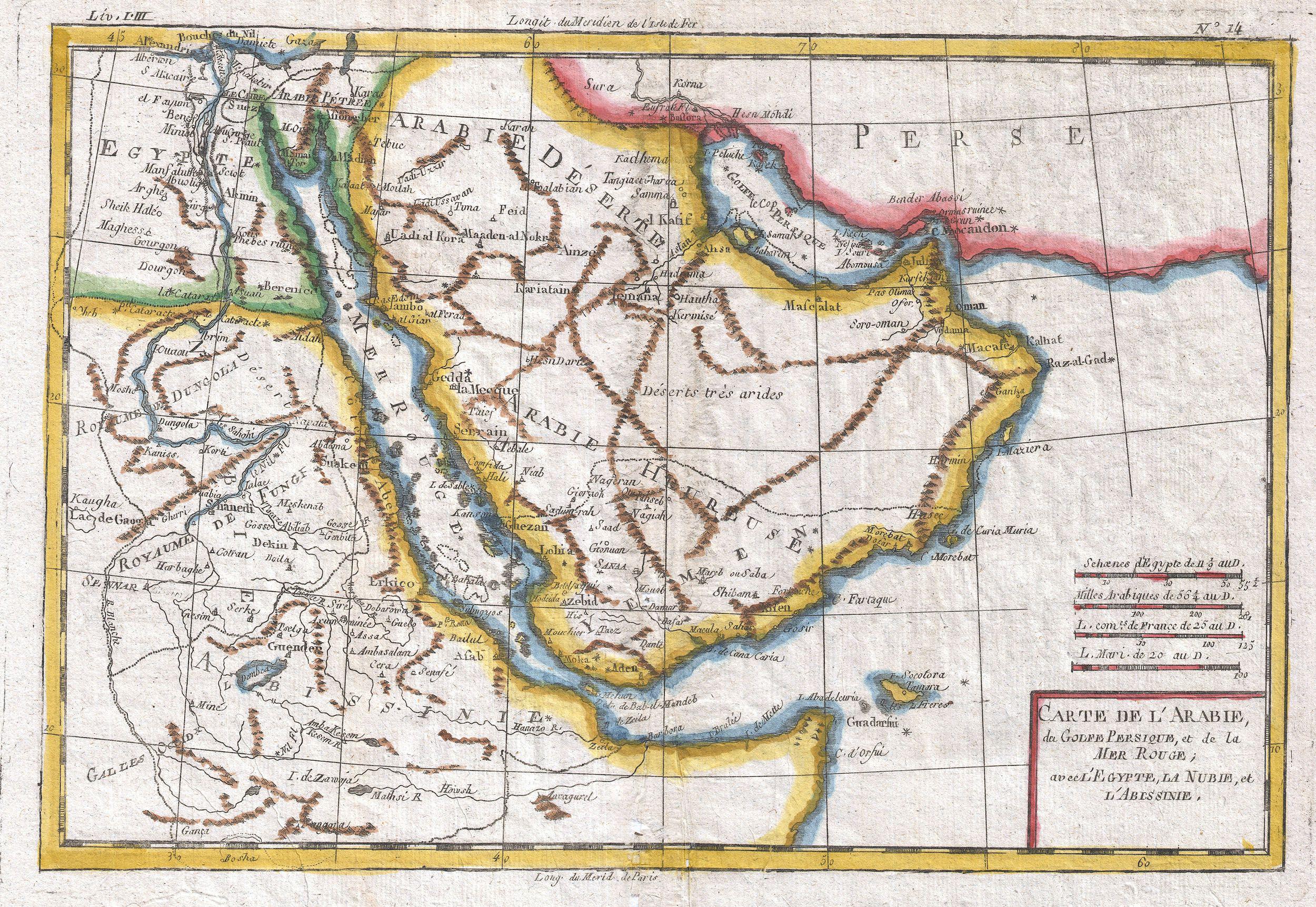
Carte De L'Arabie |
||||||||||||||||||||||
| ማጠቃለያ |
English: A fine example of Rigobert Bonne and G. Raynal’s 1780 map of the Arabia and Abyssinia (Ethiopia). Covers from the Nile Delta south as far as the Horn of Africa and West to Persia, inclusive of the modern day countries of Ethiopia, Egypt, Saudi Arabia, Yemen, Oman, Kuwait, the and the United Arab Emirates. Offers surprising detail considering that his part of the world was largely unknown to Europeans. Identifies towns, rivers, some topographical features, ports and political boundaries. Dangerous reefs and other undersea dangers that historically hindered trade in the Red Sea and the Persian Gulf are tentatively ghosted in. Drawn by R. Bonne for G. Raynal’s Atlas de Toutes les Parties Connues du Globe Terrestre, Dressé pour l'Histoire Philosophique et Politique des Établissemens et du Commerce des Européens dans les Deux Indes . |
||||||||||||||||||||||
| ቀን | 1780 (undated) | ||||||||||||||||||||||
| Dimensions | ቁመት: 9 in (22.8 cm); width: 13 in (33 cm) | ||||||||||||||||||||||
| Accession number |
Geographicus link: Arabie-bonne-1780 |
||||||||||||||||||||||
| Source/Photographer |
Raynal, G., Atlas de Toutes les Parties Connues du Globe Terrestre, Dressé pour l'Histoire Philosophique et Politique des Établissemens et du Commerce des Européens dans les Deux Indes, 1780.
|
||||||||||||||||||||||
| የማብዛት ፈቃድ (Reusing this file) |
|
||||||||||||||||||||||
የፋይሉ ታሪክ
የቀድሞው ዕትም ካለ ቀን/ሰዓቱን በመጫን መመልከት ይቻላል።
| ቀን /ሰዓት | ናሙና | ክልሉ (በpixel) | አቅራቢው | ማጠቃለያ | |
|---|---|---|---|---|---|
| ያሁኑኑ | 08:47, 24 ማርች 2011 | | 2,500 × 1,723 (1.31 MB) | BotMultichillT | {{subst:User:Multichill/Geographicus |link=http://www.geographicus.com/P/AntiqueMap/Arabie-bonne-1780 |product_name=1780 Raynal and Bonne Map of Arabia and Abyssinia |map_title=Carte De L'Arabie |description=A fine example of Rigobert Bonne and G. Raynal� |
መያያዣዎች
የሚከተለው ገጽ ወደዚሁ ፋይል ተያይዟል፦